New AI study leaves "industrial fishing's bad guys nowhere to hide"
Signify the dawning of a new era of transparency across the ocean; a new study combines satellite imagery and artificial intelligence to analyse and detect previously untraceable vessels, offering a new tool to enforce strict fishing bans in protected waters.

“The bottom line is, the bad guys don’t have anywhere to hide anymore,” smiles Enric Sala, a National Geographic Explorer in Residence, founder of Pristine Seas, and co-author on a groundbreaking new study that he anticipates will “change the game” when it comes to monitoring the illegal fishing activity taking place in the ocean’s most protected areas.
It’s a paper that is about to put the cat among the pigeons and signify the dawning of a new era of transparency across the ocean; using a combination of satellite imagery and artificial intelligence to analyse and detect previously untraceable vessels as a new tool to enforce strict fishing bans in protected waters and “hold governments and industrial fishing to account.”
It’s a bold statement, of course. But an ambition backed not only by smiles but science.
Published today in the journal Science, the new peer-reviewed paper has gone new lengths to demonstrate the power of strict legal bans against industrial fishing in marine protected areas (MPAs), finding that within these highly protected MPAs there is – on average – nine times fewer fishing vessels per square kilometre than in unprotected coastal areas.
Combining this satellite imagery and artificial intelligence, the analysis is actually a good news story on the effectiveness of MPAs, particularly those of the highest level of protection in which industrial fishing activities – such as bottom trawling – are outrightly banned.
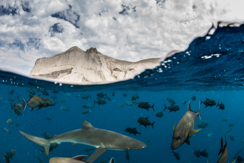
But while this study shows that some 78.5% of the 1,380 MPAs analysed indicated no signs of commercial fishing activity within them, the truth remains that significant illegal fishing activity is still taking place in many others, including within the Chagos Marine Reserve, the South Georgia and South Sandwich Islands, and the Great Barrier Reef Marine Park.
And it’s illegal fishing like this that still poses a “significant global threat”, jeopardising both the health of ocean ecosystems and the economic stability of the fishing industry.
With that in mind, why is Enric Sala smiling? because , as well as demonstrating the effectiveness of highly protected marine areas, this is a study that hails the first-ever use of a satellite technology that “lifts the veil on ‘dark fishing’, and brings to light the nefarious activities of the ocean’s bad guys.”
In other news


“It is well-known that many of these industrial fishing vessels will turn their satellite transponder off when they are about to do illegal things,” says Sala. “They are also – in some countries – known to transmit the wrong coordinates, pretending not to be fishing in these protected waters.
“But, using data from both the AIS transponders, and satellite imagery, we have been able to unveil all this ‘hidden’ fishing. And for the first time, we are able to detect illegal fishing activity in protected areas with banned industrial fishing.”
And make no mistake, this is a big step forward. Not only for the detection itself but in encouraging governments that have for too long shied away from enforcement issues or perhaps been swayed all-too-often by industrial fishing lobbyists.
“The ocean is no longer too big to watch,” adds Juan Mayorga, a scientist with Pristine Seas and another co-author on the study. “With cutting-edge satellites and AI, we’re making illegal fishing visible and proving that strong marine protections work.”
To arrive at their conclusions, researchers analysed five billion vessel positions from the Automatic Identification Systems (AIS), a GPS-based safety signal transmitted by many industrial fishing vessels, and paired this with satellite images generated by Synthetic Aperture Radar (SAR)m, which can detect vessels regardless of weather or light conditions.
The combination of the datasets – and the use of AI models developed by Global Fishing Watch – allowed researchers to detect the majority of fishing vessels over fifteen metres long, including so-called ‘dark vessels’ that do not broadcast their location and often operate to evade detection.
“No single dataset can solve the challenge of monitoring fishing activity at sea; each has its blind spots,”asserts Mayorga. “But when we combine them, their power emerges. By fusing AIS tracking with satellite radar imagery and AI, we are now much closer to the full picture of human activity across the ocean. That’s especially important in the crown jewels of the ocean – the world’s most strongly protected areas – where the stakes for enforcement and biodiversity are highest.”
Until now, inaccurate data, limited resources, and the sheer vastness of the ocean have made effectively monitoring MPAs for industrial fishing a challenge. This groundbreaking methodology offers a powerful new way to assess fishing compliance and bridge blind spots in current monitoring methods.
“It is now the responsibility of government and countries to enforce their laws,” says Sala. “They cannot argue anymore that ‘we don’t know that illegal fishing is taking place there’ because we are able to provide the evidence now to ensure that these illegal vessels can be prosecuted.”
In the same way that Sala was a part of the team that “lifted the veil’ on bottom trawling with footage captured from the seabed and shown to the world in the recent cinematic release, Ocean with David Attenborough, Sala is convinced that this too is leaving the ocean’s antagonists with “nowhere to hide.”
“With bottom trawling, we have had the evidence for a decade, when it comes to the environmental devastation and the harmful subsidies, now we know about the huge economic loss to society… yet nothing happened,” he continues. “But now that the people have seen it, now that the officials have seen it, governments are paying attention.
“I hope we will see the same effect with this. Now, this activity is detectable. And now it’s up to the concerned nations to make their marine protections enforceable.”
The reason this is important, of course, is found in the growing body of research which shows that MPAs produce spillover of fishes and invertebrates that increases the catches of species from small and sedentary (lobsters and scallops) to large and migratory, like tuna. In fact, a 2024 study revealed that fishing catch per unit effort increases, on average, 12% to 18% near the boundaries or large, fully protected MPAs.
“Illegal fishing takes place in areas of the ocean set aside for protection, but using satellites we have found – for the first time ever – that the level of protection determines how much risk industrial fishers are willing to take on,” Sala continues. “Fully and highly marine protected areas discourage illegal fishing. The stricter the rules in place to conserve ocean areas, the more benefits nations receive – including more fish to be caught outside protected areas’ boundaries.”
The study – Little to no industrial fishing occurs in fully and highly protected marine areas – is published this week in Science.


"*" indicates required fields
Printed editions
Current issue
Back issues
Back Issues
Issue 43 Sir David Attenborough’s ‘Ocean’
Enjoy so much more from Oceanographic Magazine by becoming a subscriber.
A range of subscription options are available.