Scientists begin unprecedented tests on ‘Doomsday Glacier’
The mission will deliver never-before-seen data from beneath Thwaites Glacier, helping scientists improve predictions of future sea-level rise that could affect coastal cities worldwide

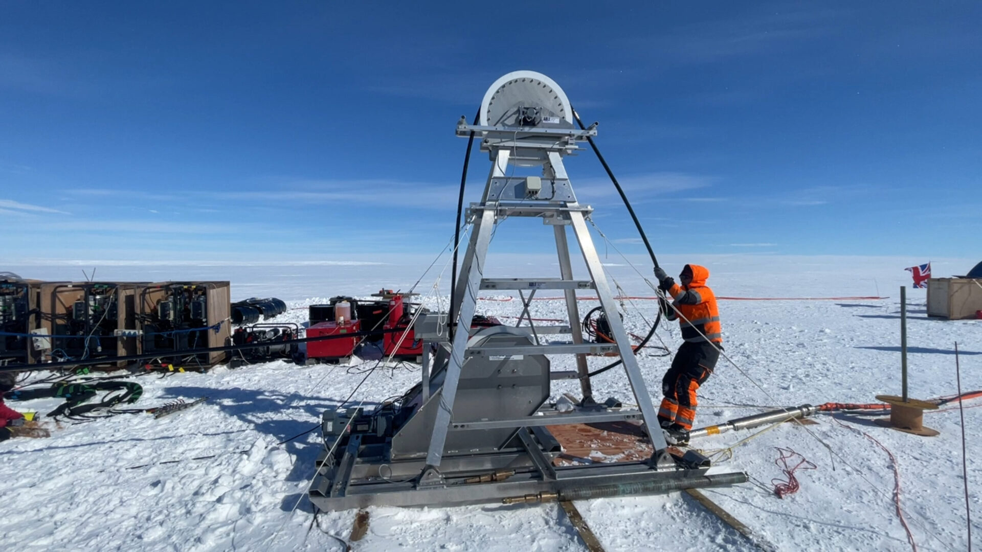
After a three-week voyage, and 17-day wait for workable conditions, researchers have finally reached the most inaccessible and least understood part of the Thwaites Glacier in West Antarctica.
Here, they will drill through the glacier to provide never-before-seen data on how the water is melting the ice from the bottom up, adding to global sea-level rise.
Thwaites Glacier – also nicknamed the “Doomsday Glacier” – is around the size of Great Britain, or the US state of Florida. Its ice is up to 2,000 metres thick in places, and if the glacier were to collapse, global sea levels would rise by 65cm.
Despite its importance, little is known about the ocean processes that drive the melting of ice from below and, until now, the main trunk of Thwaites has remained largely unexplored due to its crevassed and dynamic nature.
The team will use hot water to drill 1000m through the ice, at Thwaites’ most valuable point: where the glacier lifts off the seabed, allowing the warmest ocean water to flow under the glacier and melt it from below.
Once complete, they will lower instruments through the hole to collect the first long-term direct measurements of ocean temperature and currents at this location. The researchers will also collect sediment samples and water samples to learn more about what happened at Thwaites Glacier in the past, and what’s happening now.
Hot water drilling involves pumping 90ºC water at a high pressure through a hose. This creates a roughly 30cm diameter hole, with the hot water melting up to one metre of ice each minute.

In other news

Dr Peter Davis, a physical oceanographer at the British Antarctic Survey, said: “This is one of the most important and unstable glaciers on the planet, and we are finally able to see what is happening where it matters most.”
“This is an extremely challenging mission. For the first time we’ll get data back each day from beneath the ice shelf near the grounding line. We’ll be watching, in near real time, what warm ocean water is doing to the ice 1,000 metres below the surface. This has only recently become possible – and it’s critical for understanding how fast sea levels could rise”
Ongoing sea level rises will have a huge impact on the hundreds of millions of people on coasts from Bangladesh to low-lying Pacific islands, from New York to London.
Peter Davies, physical oceanographer, told BBC 5Live this morning that scientists don’t necessarily like the term Doomsday glacier, since it implies we have very little power in doing anything about it.
Projects like these are key to providing the scientific basis for greater action, which will help scientists improve predictions of how quickly sea levels could rise, giving governments and communities more time to plan and adapt.
Dr Won Sang Lee, a principal research scientist at the Korea Polar Research Institute and leader of the expedition said: “This is polar science in the extreme. We made this epic journey with no guarantee we’d even be able to make it onto the ice, so to be on the glacier and getting ready to deploy these instruments is testament to the skills and expertise of everyone involved from KOPRI and BAS.”
Keith Makinson, oceanographer and drilling engineer, at British Antarctic Survey said: “Over the past four decades it’s been amazing to see this technology develop, and now it’s helping to answer crucial questions about how we’re all going to be affected by climate change and rising sea levels.”


"*" indicates required fields
Printed editions
Current issue
Back issues

Enjoy so much more from Oceanographic Magazine by becoming a subscriber.
A range of subscription options are available.